Features
Geochemistry
Sample Card
Observation
Database
- Digital Field Notebook
Data Logger -
Drill Hole and Trench Logger
Lookup
List Manager GeoInfo Mobile v3.0 / GeoInfo Tools
Database - Windows Device
Lookup
List Manager GeoInfo Mobile v2.6 - Android
Mobile Device
Hardware
and Software Requirements
Version/Build
Enhancements
Download GeoInfo Mobile
v2.6 For Android User’s Manual for more details,
Downloads/GeoInfo
Mobile v2.6 User Manual.pdf.
Download GeoInfo Mobile
v3.0 for Windows User’s Manual for more details,
Downloads/GeoInfo
Mobile Users Manual.pdf.
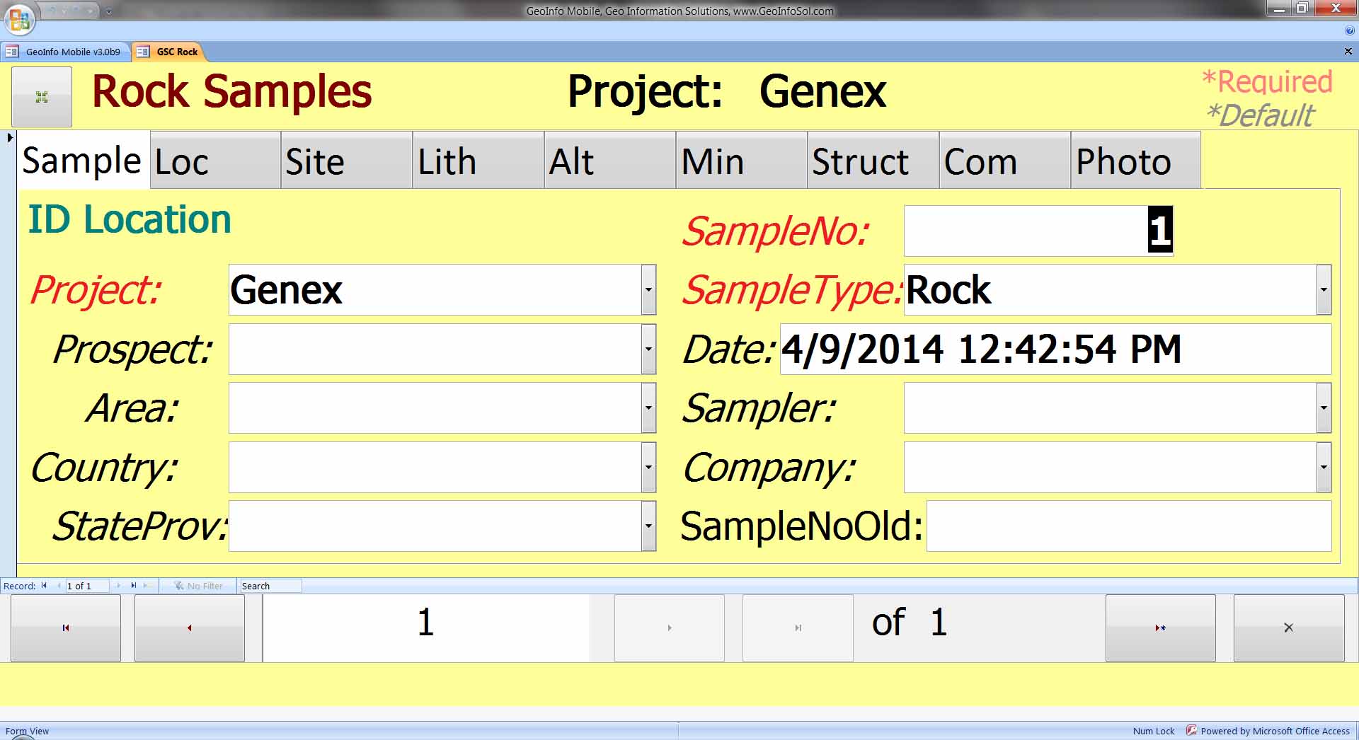
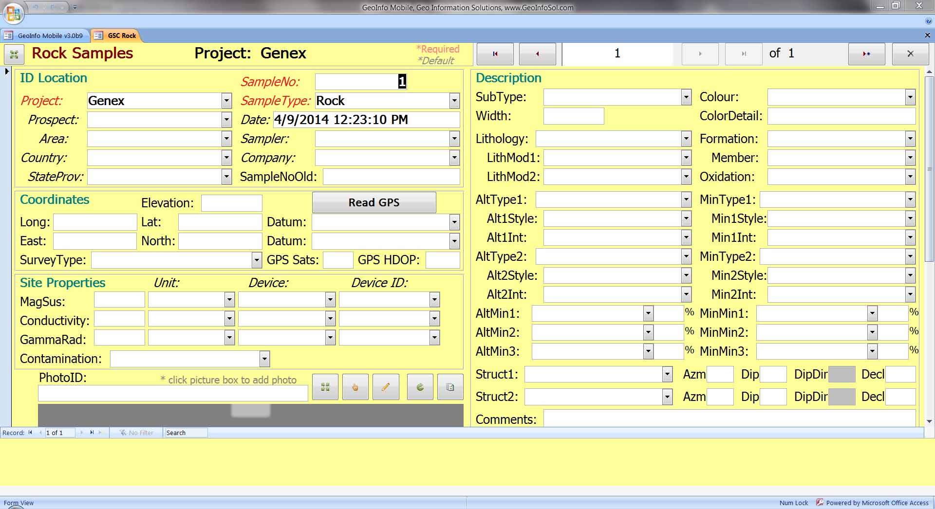
Collect attributes and locations for field
geochemistry samples.
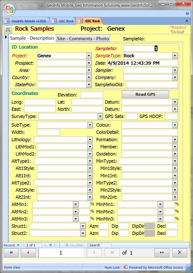
| GeoInfo Mobile v3.x
for Windows Tablet has 3 options for field
data entry; |
|
·
Mobile:
8-11 inch tablets where field and font size
needs to be bigger to operate by touch.
|
|
·
Standard
Landscape: displays greater than 11 inches
|
|
·
Portrait:
8-11 tablets.
Field size is smaller than Mobile View
and larger than Standard Landscape view.
This format also optimizes GeoInfo
Mobile content, minimizes Windows and Access
software elements, and works well with the
Windows onscreen keyboard.
|
|
GeoInfo Mobile v2.6 for Android
|
- Auto sample numbering
- Eight sample types available
- Date picker
- Pick lists for fast field data
collection, attribute standardization, and
no
typo’s.
- Many fields that are common for
each sample are defaulted for quick data
entry. Users always have the option
to change values and when changed the new
value becomes the default.
- Photos can be taken or entered
with each sample. Rather than typing
each photo name users set their cameras
photo naming prefix and suffix and then
the current photo number, GeoInfo Mobile
then builds the photo name and auto counts
the photo ID automatically for subsequent
photos.
|
 |
- Collect
Surface Geochemistry Samples for many
sample types; Rock, Soil, Stream
Sediment, Pan Con, Lag, Vegetation,
Water, and QAQC.
- Auto
sample numbering.
- QAQC
sample types include Blanks, Standards
and Field Duplicates. Field
duplicates are automatically assigned
the previous samples ‘Duplicate With’
attribute.
- QAQC
intervals can be set to remind users to
collect QAQC samples, and what type to
collect.
|
 |
- Each sample type has unique
descriptive characteristic fields
appropriate for the sample type ...
structure for Rock samples... soil horizon
for Soils ... trap type for Stream
Sediments ... etc ...
- Descriptive field types were
designed by many experience geologists and
several geochemists, with the goal in mind
of providing as many descriptive fields as
possible to the user that would facilitate
proper and thorough data analysis.
No fields are required but all are
available.
- Download the GeoInfo Mobile users
manual to review all field types for each
sample type.
- Device sensors allow your device
to be a compass, for reading Azimuth and
Dip measurements.
|

|
|

|
 |
- GeoInfo Mobile connects to an
internal GPS to automatically add GPS
coordinates to each sample.
- GPS signal quality information,
HDOP and number of satellites, is
collected with every sample.
- The automatic GPS coordinates
that are added to the database using the
Read GPS button are not editable ... a
quality control feature.
- Manually entered coordinates can
be added if needed, but should only be
done if there is a problem with the user's
standard GPS.
- The
GPS page is identical in the
Geochemistry Sample Card, Observation
Database and Data Logger tools.
|

|
Collect
all field information other than geochemistry samples
and log data
| GeoInfo
Mobile v3.x for Windows Tablet integrates
with GPS and tablet cameras. |
| Read
GPS button reads GPS Lat/Long coordinates
and automatically converts to UTM.

|
| Photo
control allows users to capture and edit photos.
|
|
| GeoInfo
Mobile v2.6 for Android |
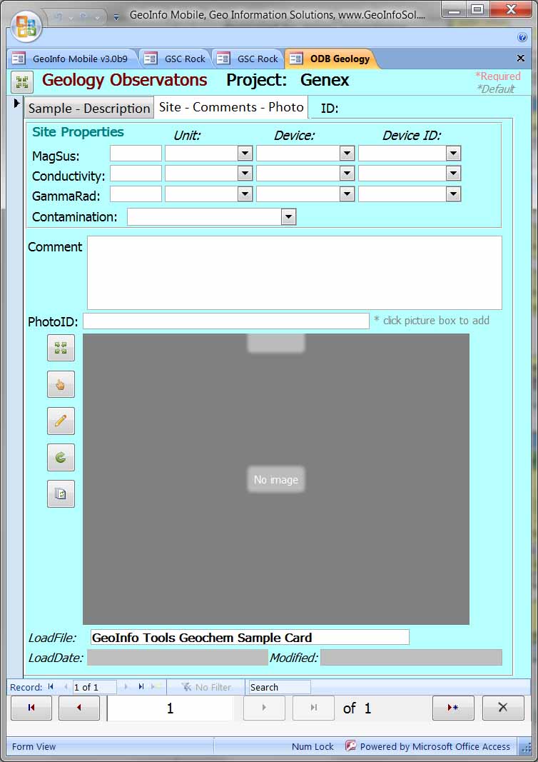
-
Observation
types exist for common field
observations and the General type can be
used for other observations. All
observations have a place in the
observation database!
-
Each
observation type has appropriate unique
attribute fields
-
Site
properties, MagSus, Conductivity and
Gamma Radiation can be collected for all
Observations and Geochemistry Samples.
-
The
Geology observation type has the same
fields as collecting a Rock sample in
the Geochemistry Sample Card. A place to
record geologic information where you do
not want to collect a rock sample.
-
The
Geology observation type is used for
field mapping.
|

|
|

|

|
|
|
|
|

|

|
- A photo can be taken with each sample, observation or logged
interval.
- Your device sensors can be used to take compass readings.
|

|
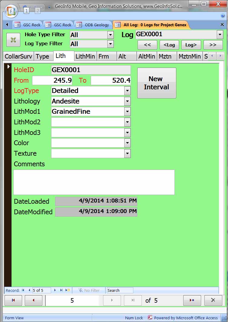
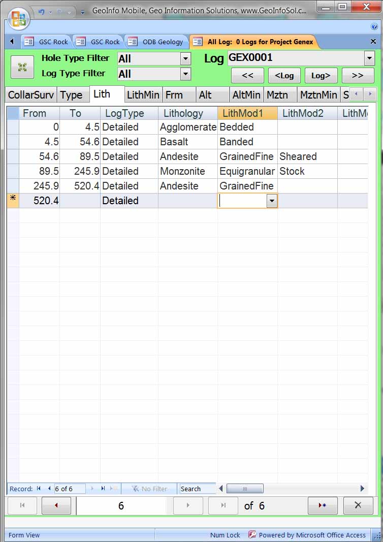
Log drill holes, trenches and underground
workings
| GeoInfo
Mobile v3.x for Windows Tablets forms
toggle between Form view or Datasheet/Log view
for ease of data entry. |
| Each log
type has its own data entry form; Collar,
Hole Type, Lithology, Alteration,
Mineralization, Minerals, Structure, Geotech,
Physical Properties, Samples, Photos and
Parameters.
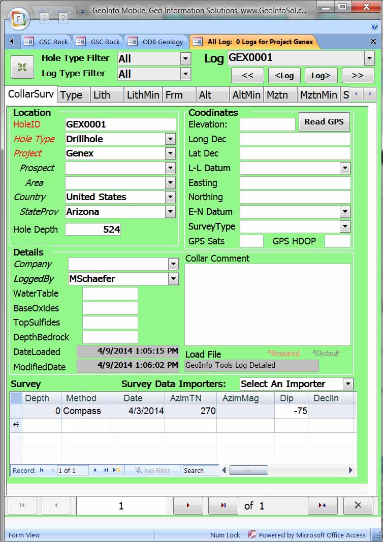
Form View
|
|
Datasheet/Log
view
|
|
|
GeoInfo Mobile v2.6
for Android
|
-
Multiple
log types for logging all geologic
characteristics of a drill hole, trench
or underground working.
-
Parameters
log can be used to log any information
that does not exist in the other logs.
-
From
is auto-defaulted to last To value for
rapid error free logging.
-
To
values are checked to make sure they are
greater than From values.
-
Users
have the option to add new intervals
(new From defaulted to old To value), or
new entries like Minerals with the same
From To.
-
List
view or Form is available.
-
Calculations
like Recovery and RQD are calculated and
displayed as required values are entered
- Photo
log can take picture from your device
camera and auto-name using Drill Hole ID
and From-To interval.
|

|
|

|

|
|

|

|
-
The
GeoInfo Mobile Settings page allows
users to set QAQC message intervals for
geochemistry samples.
-
The
GeoInfo Mobile Data page allows
Export, Import and
Clear data.Data for
each module is exported to a comma
delimited text file that can then be
loaded into a corporate database like
GeoInfo Tools, Excel, GIS or mine
modeling software. These files are
small and can easily be emailed.
-
The idea is to collect data for
a while (generally a few days to a few
weeks), export the data, send this data
to a PC where it can be loaded into a
corporate database, and then clear the
PPC database for the next field trip.
|


|
|
Master
lookup lists are managed using the Lookup
List Manger tools in GeoInfo Mobile, or the Lookup List Manger tools in
Geo-Information
Solutions GeoInfo Tools corporate
database software.
Several tools are provided in GeoInfo Tools the
database for managing this data;
including collection, importing,
exporting, viewing and completing data
analysis.
Importers for GeoInfo Mobile
export files are used to import field
data into the database.
Assay importers are then used
to link assay results with GeoInfo
Mobile field descriptions. Users of
the GeoInfo Tools database do not need
the PC Lookup List Manager software as
this functionality and more is built
into GeoInfo Tools. Contact Mike.Schaefer@GeoInfoSol.com
for more information on GeoInfo Tools
and integrating GeoInfo Mobile into a
complete corporate data solution.
Master lists are all the possible values for a
field, while the second level of
lookup list management is the
Active/Visible setting for each value
which determines what values are
visible in lookup lists in the
database collection forms.
|
|

|
-
Lookup
lists and data collection
validated using lookup lists offer
the benefit of rapid clean
standardized data entry with no
spelling/data entry errors.
GeoInfo Mobile puts
corporate data collection rules at
the rock human interface! The
GeoInfo Mobile Lookup List Manager
allows complete management of
lookup list including editing,
adding, and deleting values, as
well as Import and Export of lists
from corporate database lists.
-
There are two
levels of lookup list control in GeoInfo
Mobile. The master lists are lists
of all the possible values for a
specific field (like lithology) and are
commonly managed in GeoInfo Tools (a
corporate database available from
Geo-Information Solutions) or another
corporate database. Most times,
master lists do not need editing in
GeoInfo Mobile. The second level
of control for lookup lists is the
active/visibility setting of a specific
value in your lookup lists (what values
show up when you click a field with a
dropdown list), and are commonly
controlled by each user based on what
values they might expect or need on
their specific project or field
activity. The active/visibility
setting is commonly edited in GeoInfo
Mobile.
-
Export Lists
allows a user to export his current
lookup list values with current active
settings. If a user defines
specific lists that are appropriate for
a project, these lists can be exported
and given to other users who might be
working on the same project, so that all
users have the same active lists visible
in GeoInfo Mobile.
|

|
GeoInfo Mobile v3.x Windows Version
Software
GeoInfo
Mobile
v 3.x can run on Windows 7 through Windows 10.
GeoInfo Mobile is powered by Microsoft Access
but does not require full Access to be installed on
your computer. A
free Access 2010 runtime version can be downloaded and
installed from here; https://www.microsoft.com/en-us/download/details.aspx?id=10910.
GeoInfo Mobile v2.6 Android Version
Software
GeoInfo
Mobile
v2.6 runs on Android 2.1 and later. No
additional software is needed.
Hardware
GeoInfo
Mobile
v3.x was designed as a light weight Access database
application (GeoInfo Tools handles the heavy weight
work) and can run on minimal hardware.
Small Windows tablets with Intel Atom
processors and 2 GB of memory work well, 32 GB of
storage is sufficient however 64 GB is recommended if
GIS field navigation software is going to be
integrated with GeoInfo Mobile.
GeoInfo Mobile
v2.6 was designed as a light weight Android app to run
on small handheld devices like phones or rugged field
data collectors
V3.0
V2.6(new in 2020)
V2.5(end of Windows Mobile support)
V2.4
V2.3
V2.1
V2.0
V1.8
V1.7
-
Add MagSus, Conductivity, and Gamma
Radiation physical property fields to samples and
observations,2007
V1.6
-
Node licensing
-
QAQC interval messages
- 2007
V1.5
V1.4
V1.0 - V1.3

|